This posting was updated January 1, 2013 to reflect information from a newspaper article in The Times Record.
When I was a child, the road to Grandma’s house was New York Route 2, leading from our home in Troy over Grafton Mountain to the small town of Petersburg. Our family’s many trips there are the earliest road trips I recall.
Petersburg (sometimes spelled Petersburgh) was founded in 1791 and once had railroad service, but the 20th Century and automobile travel brought many changes to the town. Most noteworthy was the construction of the Taconic Trail, a modern highway through Petersburg Pass connecting the town to Williamstown, Massachusetts and the Mohawk Trail.
(Note that the Taconic Trail is unrelated to the Taconic Parkway, a separate north-south highway connecting New York City to the New York Thruway Berkshire Spur near Chatham.)
The road into Petersburg begins with a steep decline and the junction with NY 22, a north-south highway running from New York City to the Canadian border along the state’s eastern edge. This junction is shown in an early postcard:
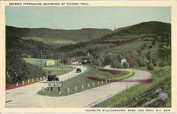
The road to the right leads to Route 22; the road to the left traverses a stone overpass and leads into the town center. The same highway configuration exists today.
Petersburg once had three general stores, but by my lifetime only one remained in operation. It was built by Fred Nichols in 1892 and this early postcard shows the “Nichols Block.” Later the store was Waters & Sawyer, later operated by Mary Sawyer, then Vern O’Dell and finally Ziggie Krahforst before closing for good in the 1980s.
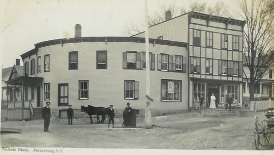
A nearly identical view of this store published in Petersburgh Then and Now: A Photographic Comparison by Peter R. W. Schaaphok (which I used as a reference) shows a sign in the window “SOUVENIR POSTCARDS – PETERSBURG VIEWS.” Another photo of the nearby Sawyer, Moses, and Hewitt store also had a sign “PETERSBURG VIEWS.”
The other side of the Nichols building (which originally would have been considered the back of the building) faced the highway and was much more visible to automobile travelers through town. This side of the building featured a soda fountain, complete with a counter and stools. As best I can remember its styling, I would estimate it was of 1930s – 1940s vintage. On Sunday mornings I would come here with Grandpa, and while he bought a half gallon of ice cream to have with dinner, I would spin around on the stools and buy a gumball out of the penny gumball machine. Mary Sawyer ran the store then.
Then, one sad day in 1961, things changed forever. An asphalt truck went out of control on the steep decline leading into the town center. Unable to negotiate the curve in the road, the truck went straight into the store, demolishing its corner. The soda fountain and counter were a total loss.
Grandpa went out with his camera and took this picture:
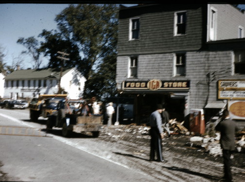
Sawyer’s Store, Petersburg, NY. Kodachrome slide by Ralph Babcock, 1961
The incident was reported on the front page of Troy, NY’s evening newspaper, The Times Record, on September 22, 1961. The newspaper can be viewed here and features a photo taken from the same angle as Grandpa’s slide. The article continues here with a second photo showing the counter with the stool posts knocked askew. Unfortunately, a woman was sitting on one of the stools at the time of the incident and was buried in hot asphalt.
The corner of the store was rebuilt, but the soda fountain never was. In its place were some ordinary shelves for ordinary store merchandise. But the disappointment I felt then, on the eve of my sixth birthday, over the loss of the soda fountain seemed to predict the roadside enthusiast I would become.
A little farther to the east, the highway crosses the Little Hoosick River. The crossing was once a covered bridge, and later two concrete bridges (called “Upper bridge” and “Lower bridge” by the locals) were built in town. But when the Taconic Trail was built, the upper bridge was replaced with an especially ornate concrete bridge:
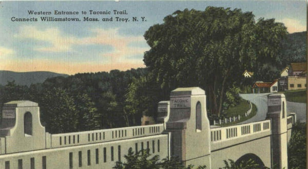
This bridge was rebuilt in recent years, retaining the original look as much as possible.
Along the right edge of the above postcard, you will notice a white building with roof protruding toward the road, with a gray concrete block building adjacent. These buildings were part of Hillcrest, a “Gas Food Lodging” complex for automobile travelers.
Here’s a postcard view of Hillcrest Cabins:
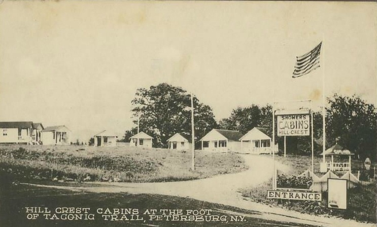
And here’s the white building in the bridge postcard, featuring a small restaurant with gas pumps out front. The concrete block building, with automobile service bays, came later. At some point (I’m guessing in the 1950s) they switched to selling Mobil instead of Shell gasoline. I remember the concrete block building painted white with “Mobilgas Mobiloil Mobilubrication” lettering and Mobil’s trademark red Pegasus.
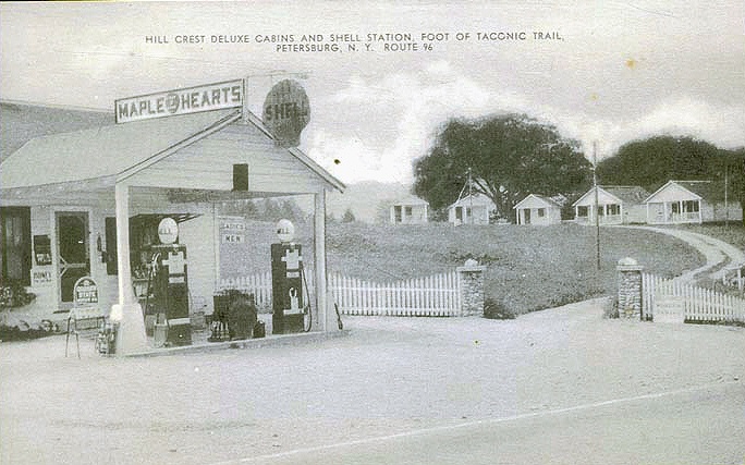
You will notice this postcard states “Route 96,” which was the earlier route designation of the Taconic Trail. In order to create a more logical east-west routing from the Mohawk Trail to the Taconic Trail, the route number was changed to Route 2, the number used on the Mohawk Trail in Massachusetts. New York did this by swapping Routes 2 and 96, with the previous Route 2, from Rochester to Owego, becoming Route 96.
If a cabin at Hillcrest was too modest for your taste, there were billboards enticing travelers to travel a few more miles to Williamstown for their night’s stay. Petersburg once had billboards for the 1896 House, Berkshire Hills Motel, and the Williams Inn, the first lodging in the Treadway Inns chain. And all three of these remain in business today (although the Williams Inn is no longer a Treadway. The only remaining Treadway Inn using that name is in Owego, NY, by coincidence an end point on the present Route 96.)
Traveling further east, the Taconic Trail winds and climbs a few more miles to the top, directly on the New York – Massachusetts state line. There once was a summit house and observation tower, much like similar ones along the Mohawk Trail:
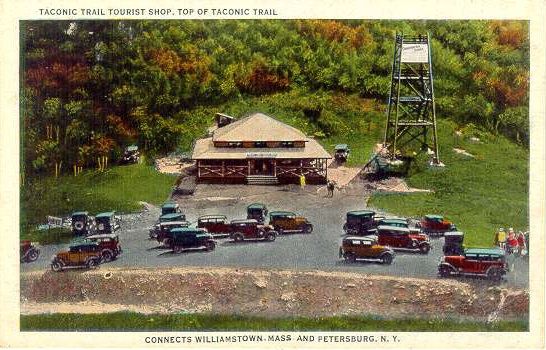
In 1962, Petersburg Pass Ski Area was opened and the summit house became a base lodge. The observation tower was still there, but was allowed to deteriorate and was no longer open to the public (another childhood disappointment.)
You can read more about Petersburg Pass Ski Area here.
The base lodge (original summit house) was destroyed by fire in the early 1970s. A new base lodge was built further from the highway and the ski area was reopened as Taconic Trails Ski Area, later Mount Raimer (after the owner.) The new lodge was also destroyed by fire and by 1980 the mountain’s days as a ski area were over.
Today, there’s ample parking at the summit, although there are no facilities. You can stop and enjoy the view or access several hiking trails. The Taconic Trail then continues down the other side of the mountain in Massachusetts, ending at US Route 7. Route 2 then follows Route 7 to the Williamstown town green a couple of miles to the north before heading east to North Adams and the Mohawk Trail.

Error thrown
Call to undefined function ereg()